Hertfordshire
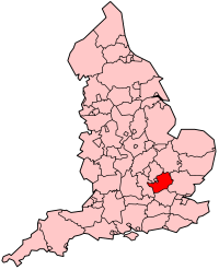
Hertfordshire's Location within England |
|
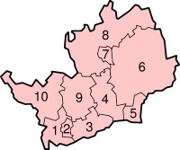
-
Three
Rivers
-
Watford
-
Hertsmere
-
Welwyn Hatfield
-
Broxbourne
-
East Hertfordshire
-
Stevenage
-
North Hertfordshire
-
St Albans
-
Dacorum
|
Hertfordshire
(pronounced "Hartfordshire" and abbreviated as "Herts")
is an inland county in the United Kingdom, officially part of the East
of England Government region. It is one of the Home Counties.
Hertfordshire
is located to the north of Greater London, and much
of the county is part of the London commuter belt.
To the east of Hertfordshire
is Essex, to the west is Buckinghamshire
and to the north are Bedfordshire, Luton
and Cambridgeshire.
The highest point
in the county is 803 feet (245 m) above sea level, a quarter mile (400
m) from the village of Hastoe
near Tring.
The county motto is
"Trust and fear not".
| Geography |
| Status |
Ceremonial &
Non-metropolitan county |
| Origin |
Historic |
| Region |
East of England |
Area
- Total
- Admin. Council |
Ranked 36th
634 miles² (1,643 km²)
Ranked 32nd |
| Admin HQ |
Hertford |
| ISO 3166-2 |
GB-HRT |
| ONS code |
26 |
| NUTS 3 |
UKH23 |
| Demographics |
Population
- Total (2004 est.)
- Density
- Admin. Council
|
Ranked 16th
1,041,300
634 / km²
Ranked 6th |
| Ethnicity |
93.7% White
3.0% S. Asian
1.1% Afro-Carib. |
| Politics
|
| Executive |
Conservative |
| Members of Parliament |
James Clappison
Barbara Follett
David Gauke
Oliver Heald
Peter Lilley
Anne Main
Mike Penning
Mark Prisk
Grant Shapps
Charles Walker
Claire Ward |
History
Hertfordshire
was originally the area assigned to a fortress constructed at Hertford
under the rule of Edward the Elder in 913. The name Hertfordshire
appears in the Anglo-Saxon Chronicle in 1011.
The Domesday Book
recorded the county as having nine hundreds. Tring and Danais became one,
Dacorum. The other seven were Broadwater, Cashio, Edwinstree, Hertford,
Hitchin and Odsey.
Hertfordshire
is the starting point of the New River: a man made waterway, opened in
1613 to supply London with fresh drinking
water.
In the 1965, under
the London Government Act 1963, Barnet Urban District and East Barnet
Urban District were abolished and their area transferred from Hertfordshire
to Greater London to form part of the London Borough
of Barnet. At the same time the Potters Bar Urban District was directly
transferred from Middlesex to Hertfordshire.
On the morning of
11 December 2005, a large explosion and fire occurred at a petroleum fuel
depot near Hemel Hempstead.
Forty three people were injured, and considerable damage caused. The two
day fire was the largest in peacetime Europe, and a pall of smoke darkened
London and much of South East England.
Geology
The rocks of the English
county of Hertfordshire belong to the great
shallow syncline known as the London basin, the beds dip in a south-easterly
direction towards the syncline's lowest point roughly under the River
Thames. The most important formations are the Cretaceous chalks, which
are exposed as the high ground in the north and west of the county, and
the Tertiary rocks made up of the Paleocene age Reading Beds and Eocene
age London Clay that occupies the remaining southern part.
The Cretaceous
On the northern boundary
and just inside the county, at the foot of the chalk Chiltern Hills, near
Tring and Ashwell,
there is a small strip of exposed Cretaceous Gault Clay and Upper Greensand.
At 100 million years old, these are the oldest rocks in the county. Rocks
get progressively younger as one moves in a south easterly direction through
the county.
The lowest layer of
the chalk is the Chalk Marl, which, with the Totternhoe Clunch Stone above
it, lies at the base of the Chiltern Hills escarpment. This is visible
as a terrace projecting north-westwards, near Whipsnade and Ivinghoe.
Above these beds,
the Lower Chalk, without flints, rises up sharply to form the steepest
part of the Dunstable Downs, which are the easterly continuation of the
Chiltern Hills.
Next comes the Chalk
Rock, which, being a hard bed, caps the hilltops by Boxmoor, Apsley End
and near Baldock. The Upper
Chalk slopes southward towards the Tertiary boundary to the south.
All the chalk was
deposited between 100 million and 65 million years ago when the area was
at the bottom of a shallow sea and some distance from the nearest land.
The chalk is often
covered by a clay-with-flints deposit, which is formed of the weathered
remnants of Tertiary rocks and chalk.
The Tertiary
The Palaeocene Reading
beds consist of mottled and yellow clays and sands, the latter are frequently
hardened into masses made up of pebbles in a siliceous cement, known locally
as Hertfordshire puddingstone. Examples of Reading Beds outliers occur
in what are otherwise chalky areas at St
Albans, Ayot Green, Burnham
Green, Micklefield Green, Sarrat, and Bedmond. The Reading Beds were laid
down about 60 million years ago when the area was a river estuary receiving
river sediment from land to the west.
The London Clay is
a stiff, blue clay that weathers to brown and rests nearly everywhere
upon the Reading beds. It represents the time 55 to 40 million years ago
when Hertfordshire was once again under a
deeper sea but was near enough to land to receive fine mud deposits.
The Ice Age
About 500,000 years
ago during the ice age period known as the Anglian glaciation, glaciers
approached from the North Sea and reached as far south-west as Bricket
Wood. Glacial gravels and boulder clays cover a great deal of the
whole area to the north east of the county and the Upper Chalk itself
has been disturbed at Reed and Barley by glaciation.
Prior to the ice ages
the River Thames followed a path through the southern part of Hertfordshire,
running from the area of modern Staines up the valley of the Colne to
Hatfield and then eastward
across Essex originally towards the primeval Rhine
but later down the valley of the modern River Lea. This path was blocked
by a mass of ice near Hatfield
and a lake ponded up to the west of this around St
Albans. Waters eventually overflowed near Staines to cut the path
of the modern Thames through central London.
When the ice retreated about 400,000 years ago the river bed along the
new route followed the lower path and so the river remained on its present
day course. The flow in the Colne valley reversed, now flowing south as
a tributary into the modern Thames. Superficial gravel deposits from the
primordial Thames, are found throughout the Vale of St.
Albans.
At the retreat of
the glaciers, wind blown powdered rock known as loess was deposited over
the whole county, forming thin layers under a meter thick. This makes
for fine, easily cultivated and fertile soils.
Urban Areas
These are the main
towns in Hertfordshire.
Places of interest
- Aldenham Country
Park
- Beech Bottom Dyke,
St Albans - large scale iron age defensive or boundary ditch
- Berkhamstead Castle
- De Havilland Aircraft
Heritage Centre, Salisbury Hall, between London Colney and South Mimms
- Hatfield House
: Jacobean house, gardens and park
- Henry Moore Foundation,
Much Hadham - Sculpture park on the work of Henry Moore
- Knebworth House
- 250 acres (1.0 km²) of country park, venue of regular rock and
pop festivals.
- St Albans Cathedral
- Shaw's Corner,
Ayot St Lawrence, home of George Bernard Shaw.
- The Six Hills
Roman site in Stevenage.
- Stevenage, the
first UK New Town
- Sopwell Nunnery,
St Albans
- The University
of Hertfordshire was created from Hatfield Polytechnic which originated
in Hatfield.
- Verulamium Roman
town remains at St Albans
- Ye Olde Fighting
Cocks, St Albans - a claimant to being the oldest pub in Britain.
|