Leicestershire
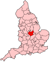
Leicestershire's Location within England |
|
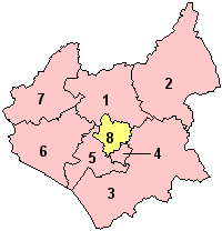
- Charnwood
- Melton
- Harborough
- Oadby and
Wigston
- Blaby
- Hinckley
and Bosworth
- North West
Leicestershire
- Leicester
(Unitary)
|
Leicestershire
(abbreviated Leics) is a landlocked county in central England.
It takes its name from the heavily populated City
of Leicester: traditionally its administrative centre, although the
City of Leicester unitary
authority is today administered separately from the rest of Leicestershire.
The county borders onto Lincolnshire, Rutland,
Northamptonshire, Warwickshire,
Staffordshire, Derbyshire,
and Nottinghamshire.
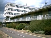
County Hall, situated
in Glenfield, about 5 km
(3 miles) northwest of Leicester
city centre, is the seat of Leicestershire County Council and the headquarters
of the county authority. The City
of Leicester is administered from offices in Leicester
itself and the City Council meets at Leicester Town Hall.
The River Soar rises
to the east of Hinckley, in
the far south of the county, and flows northward through Leicester
before emptying into the River Trent at the point where Derbyshire,
Leicestershire, and Nottinghamshire
meet. A large part of the northwest of the county, around Coalville,
forms part of the new National Forest area extending into Derbyshire
and Staffordshire. The highest point of the
county is Bardon Hill at 278m/912ft, which is also a Marilyn.
| Geography |
| Status |
Ceremonial &
(smaller) Non-metropolitan county |
| Region |
East Midlands |
Area
- Total
- Admin. Council
- Admin Area |
Ranked 28th
2,156 km²
Ranked 26th
2,083 km² |
| Admin HQ |
Glenfield
|
| ISO 3166-2 |
GB-LEC |
| ONS code |
31 |
| NUTS 3 |
UKF22 |
| Demographics |
Population
- Total (2004 est.)
- Density
- Admin. Council
- Admin Pop.
|
Ranked 21st
909,000
421 / km²
Ranked 17th
623,900 |
| Ethnicity |
85.0% White
11.9% S.Asian
1.2% Afro-Carib. |
| Politics
|
| Executive |
Conservative
|
| Members of Parliament |
Stephen Dorrell,
Alan Duncan, Edward Garnier, Patricia Hewitt, Andy Reed, Andrew Robathan,
Peter Soulsby, David Taylor, David Tredinnick, Keith Vaz |
History
 Leicestershire
was recorded in the Domesday Book in four wapentakes: Guthlaxton, Framland,
Goscote and Gartree. These later became hundreds, with the division of
Goscote into West Goscote and East Goscote, and the addition of Sparkenhoe
hundred. Leicestershire
was recorded in the Domesday Book in four wapentakes: Guthlaxton, Framland,
Goscote and Gartree. These later became hundreds, with the division of
Goscote into West Goscote and East Goscote, and the addition of Sparkenhoe
hundred.
Leicestershire's external
boundaries have changed little since the Domesday Survey. The Measham-Donisthorpe
exclave of Derbyshire has been exchanged for
the Netherseal/Overseall area, and the urban expansion of Market
Harborough has caused Little
Bowden, previously in Northamptonshire
to be annexed.
In 1974, the Local
Government Act 1972 abolished the county borough status of Leicester
city and the county status of neighbouring Rutland,
converting both to administrative districts of Leicestershire.
These actions were reversed on 1 April 1996, when Rutland
and the City of Leicester
became unitary authorities.
Demographics
The population of
Leicestershire (excluding the
city of Leicester) is 609,579
(2001). The county covers an area of 2,084 sq km (804 sq mi).
The largest population
centre is Leicester, followed
by Loughborough. Other
major towns include Ashby-de-la-Zouch,
Coalville, Hinckley,
Market Harborough,
Melton Mowbray, Oadby
and Wigston.
Places of interest
- Ashby Canal
- The Battlefield
Line (a heritage railway)
- Belvoir Castle
- Bosworth Battlefield
- Bradgate Park
- Brampton Valley
Way (linear park and foot/cycle path to Northampton)
- Donington Park
- Nottingham East
Midlands Airport
- Foxton Locks
- The Great Central
Railway, Loughborough
- High Cross
- Launde Abbey
- Leicester Botanic
Gardens
- Moira Furnace
- Stanford Hall
- Twycross Zoo
|