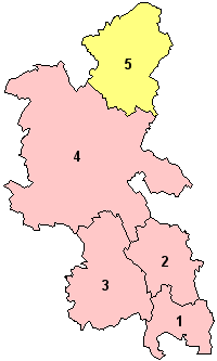
Buckinghamshire
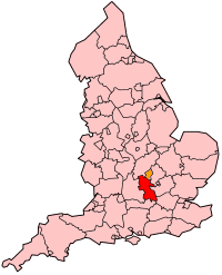
Buckinghamshire's Location within England |
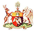
Buckinghamshire's Coat of Arms |
-
South
Bucks
-
Chiltern
-
Wycombe
-
Aylesbury Vale
-
Milton
Keynes (Unitary)
|
Buckinghamshire
(abbreviated Bucks) is a county in South East England. The county town
is Aylesbury.
Buckinghamshire
is divided into four districts, Aylesbury Vale, Chiltern, South Bucks
and Wycombe. The ceremonial county (which is based on the post-1974 administrative
county) also includes Milton Keynes.
The ceremonial county
borders onto those of Oxfordshire, Northamptonshire,
Bedfordshire, Hertfordshire,
Berkshire and Greater London.
In the local government reform of 1974, Buckinghamshire
lost Slough and Eton
to Berkshire; these areas have been administered
under the unitary authorities of Slough
and Windsor and Maidenhead since 1998. Milton Keynes and district became
a unitary authority in 1997.
It is an agricultural
county, covering part of the Chiltern Hills to the South and the Vale
of Aylesbury to the north. The highest point is Coombe Hill near Wendover
at 876 feet (267 m) above sea level. It has fertile agricultural lands,
with many landed estates, especially those of the Rothschild family in
the 19th century. Industry is mainly agricultural, with furniture-making
traditionally centred at High
Wycombe, pharmaceuticals, service and distribution industries. There
are some residential commuter areas for London in
the south.
| Geography |
| Status |
Ceremonial
& (smaller) Non-metropolitan county
Traditional
county |
| Region |
South East England
|
Area
- Total
- Admin Council
- Admin Area |
Ranked 32nd
724 miles² (1,874 km²)
Ranked 33rd
1,565 km² |
| Admin HQ |
Aylesbury |
| ISO 3166-2 |
GB-BKM |
| ONS code |
11 |
| NUTS 3 |
UKJ13 |
| Demographics |
Population
- Total (2003 est.)
- Density
- Admin Council
- Admin Pop
|
Ranked 31st
693,675
370 / km²
Ranked 29th
477,960 |
| Ethnicity |
91.7% White
4.3% S.Asian
1.6% Afro-Carib. |
| Politics
|
| Executive |
Conservative |
| Members of Parliament |
John Bercow
Cheryl Gillan
Paul Goodman
Dominic Grieve
Mark Lancaster
David Lidington
Phyllis Starkey |
Administration
 The
modern county of Buckinghamshire is administered
by Buckinghamshire County Council. The county council was founded in 1889
with its base in new municipal buildings in Walton Street, Aylesbury
(which are still there). In Buckinghamshire local administration is run
on a two-tier system where public services are split between the county
council and a series of district councils. The
modern county of Buckinghamshire is administered
by Buckinghamshire County Council. The county council was founded in 1889
with its base in new municipal buildings in Walton Street, Aylesbury
(which are still there). In Buckinghamshire local administration is run
on a two-tier system where public services are split between the county
council and a series of district councils.
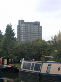
In the 1960s the council
moved into new premises: a 15-storey tower block in the centre of Aylesbury
(pictured) designed by architect Thomas Pooley. Said to be one of the
most unpopular and disliked buildings in Buckinghamshire
it is now a Grade II listed building.
In 1997 the northern
part of Buckinghamshire in Milton Keynes
Borough separated to form its own single-tier local administration system
however for ceremonial and some other purposes Milton Keynes is still
considered to be part of Buckinghamshire.
History
The name Buckinghamshire
is Anglo Saxon and means The district (scire) of Bucca's home. Bucca's
home refers to Buckingham
in the north of the county, and is named after an Anglo-Saxon landowner.
The county has been so named since about the 12th century; however, the
county itself has been in existence since it was a subdivision of the
kingdom of Mercia (585–919).
Some of the settlements
in Buckinghamshire date back much further
than the Anglo-Saxon period. Aylesbury,
for example, is known to date back at least as far as 1500 B.C.. There
are a wealth of places that still have their Brythonic names (Penn,
Wendover), or a compound of
Brythonic and Anglo Saxon (Brill,
Chetwode, Great
Brickhill) and there are pre-Roman earthworks all over the county.
Also, one of the most legendary kings of the Britons, Cunobelinus, had
a castle in the area (the earthworks of which still remain) and lent his
name to the group of villages known as the Kimbles.
The Roman influence
on Buckinghamshire is most widely felt in
the Roman roads that cross the county. Watling Street and Akeman Street
both cross the county from east to west, and the Icknield Way follows
the line of the Chiltern Hills. The first two were important trade routes
linking London with other parts of Roman
Britain, and the latter was used as a line of defence, though it may have
been an extension of a much older road.
The single group of
people who probably had the greatest influence on Buckinghamshire's history,
however, are the Anglo-Saxons. Not only did they give the county and most
of the places within it their names, but the modern geography of the county
is largely as it was in the Anglo-Saxon period. One of the great battles
worthy of mention in the Anglo-Saxon Chronicle was fought between Cerdic
of Wessex and the Britons at Chearsley,
no fewer than three saints from this period were born in Quarrendon
and in the late Anglo-Saxon period a royal palace was established at Brill.
The sheer wealth in the county was worthy of note when the Domesday Survey
was taken in 1086.
The Plantagenets continued
to take advantage of the wealth of the county. William the Conqueror annexed
most of the manors for himself and his family: Odo, Bishop of Bayeux,
William's half brother, became a major landowner locally. Many ancient
hunts became the king's property (worthy of note are Whaddon
Chase and Princes
Risborough) as did all the wild swans of England.
The ancient tradition of breeding swans in Buckinghamshire
for the king's pleasure later provided the heraldic supporter for the
county's coat of arms (see below).
Another flush of annexations
of local manors to the Crown accompanied the dissolution of the monasteries
(1536), when almost a third of the county became the personal property
of King Henry VIII, to dispose of at his pleasure. Henry VIII was also
responsible for making Aylesbury
the county town over Buckingham,
which he did to curry favour with Thomas Boleyn so that he could marry
his daughter Anne. Another of Henry's wives, Catherine Parr, also had
a sphere of influence within the county.
In the English Civil
War (1642–1649) Buckinghamshire was
mostly Parliamentarian, although some pockets of Royalism did exist. The
Parliamentarian hero John Hampden was from Buckinghamshire,
and he helped defend Aylesbury
in battle in 1642. Some villages to the west of the county (Brill
and Boarstall for example)
were under constant conflict for the duration of the war, given their
equidistance between Parliamentarian Aylesbury
and Royalist Oxford. Many of these
places were effectively wiped off the map from the conflict, but have
since been rebuilt.
The Industrial Revolution
and the arrival of the railway completely changed the landscape of certain
parts of the county. Wolverton
in the north (now part of Milton Keynes) became a national centre for
railway carriage construction and furniture and paper industries took
hold in the south. In the centre of the county, the lace industry was
introduced and grew rapidly, because it gave employment to women and children
from poorer families. Buckinghamshire still
has good rail links to London, Birmingham
and Manchester and furniture
is still a major industry in parts of south Bucks.
In the early to mid
Victorian era a major cholera epidemic and agricultural famine took their
hold on the farming industry which for so many years had been the stable
mainstay for the county. Migration from the county to nearby cities and
abroad was at its height at this time, and certain landowners took advantage
of the cheaper land on offer that was left behind. One of the county's
most influential families arrived in Bucks
as a result of this, the Rothschilds, and their impact on the county's
landscape was huge.
Mass urbanisation
of the very north and south of the county took place in the 20th century,
which saw the new towns of Milton
Keynes and Slough being formed.
This was a natural extension of the industrialisation of the landscape,
and provided much needed employment for many local people. Both have since
become unitary authorities in their own right, reducing the land area
of Buckinghamshire by almost a third.
Today Buckinghamshire
is considered by many to be the idyllic rural landscape of Edwardian fiction
and is known colloquially as leafy Bucks. This point of view has led to
many parts of the county being very popular with commuters for London,
which in turn has led to an increase in the general cost of living for
local people. However pockets of deprivation still remain in the county,
particularly in the large towns of Aylesbury
and High Wycombe.
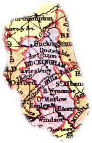
1904 Map of Buckinghamshire
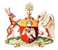
Coat of Arms
The
coat of arms for Buckinghamshire County Council features a white swan
in chains. This dates back to the Anglo Saxon period, when swans were
bred in Buckinghamshire for the king's pleasure.
That the swan is in chains illustrates that the swan is bound to the king,
an ancient law that still applies to wild swans in the UK today. The herald
was first used at the Battle of Agincourt by the Duke of Buckingham.
Above the swan is
a gold band, in the centre of which is Whiteleaf Cross, representing the
many ancient landmarks of the county. The shield is mounted by a beech
tree, representing the Chiltern Forest that once covered almost half the
county. Either side of the shield are a stag and a swan.
The motto of the shield
says Vestigia Nulla Retrorsum. This is Latin and means 'no stepping back'.
Places in Buckinghamshire
This is a list of
the towns in the county of Buckinghamshire.
Buckinghamshire
was subdivided into 18 hundreds at the time of the Domesday Book. These
later consolidated to eight — Aylesbury,
Ashendon, Buckingham,
Burnham, Cottesloe,
Desborough, Newport
and Stoke. Burnham,
Desborough and Stoke
are collectively known as the Chiltern Hundreds and are used as a pretext
for resignation from the House of Commons.
Places Traditionally in Buckinghamshire
This is a list of
the towns in the traditional county of Buckinghamshire
that after various local government reorganisations are no longer adminstered
by it.
Places of Interest
- Ascott
- Ashridge
Estate
- Bletchley
Park
- Boarstall
Tower
- Bradenham
Village
- Buckingham
Chantry Chapel
- Buckinghamshire
County Museum
- Buckinghamshire
Railway Centre in Quainton
- Chequers
Court
- Chicheley
Hall
|
- Chinnor &
Princes Risborough Railway
Claydon House
- Cliveden
- Coombe Hill
- Country
Parks
- Country
Walks and Rights of Way
- Dorneywood
- Halton House
- Hampden
House
- Hartwell
House
- Hughenden
Manor
|
- Kederminster
Library
- The King's
Head Inn, Aylesbury
- Long Crendon
Courthouse
- Mentmore
Towers
- Pitstone
Windmill
- Princes
Risborough Manor House
- Roald Dahl
Children's Gallery
- Roald Dahl
Museum and Story Centre
|
- Shardeloes
- Stowe Park
- Waddesdon
Manor
- West Wycombe
Caves
- Walks by
bus and rail
- West Wycombe
Park
- West Wycombe
Village
- Whiteleaf
Cross
- Winslow
Hall
- Wycombe
Abbey
|
Famous People
The following people
are either from Buckinghamshire, have lived
in Buckinghamshire, or continue to live
in Buckinghamshire.
- Nancy Astor, politician
and society hostess, lived in Cliveden
- Nick Beggs, musician,
is from Winslow
- Lynda Bellingham,
actress, is from Aylesbury
- Cilla Black, television
presenter, lives in Denham
- Enid Blyton, writer,
lived in Beaconsfield
- Anne Boleyn, second
wife of King Henry VIII, had a house in Wendover
- Melanie Brown,
musician, lives in Little
Marlow
- John Craven, television
presenter, lives in Princes
Risborough
- Peter Carington,
6th Baron Carrington, politician, lives in Bledlow
- Roald Dahl, writer,
lived in Great Missenden
- Benjamin Disraeli,
1st Earl of Beaconsfield, politician, lived at Hughenden
Manor
- Iain Duncan Smith,
politician, lives in Swanbourne
- Ian Dury, musician,
lived in Wingrave
- Noel Edmonds,
television presenter, once lived in Weston
Turville
- Edward the Confessor,
king of England, had a palace in Brill
- T.S. Eliot, writer,
lived in Marlow
- Frederick, Prince
of Wales lived in Cliveden
- Noel Gallagher,
musician, lives in Little
Chalfont
- Sir John Gielgud,
actor, was living in Wotton
Underwood when he died
- Martin Grech,
musician, is from Aylesbury
- John Hampden,
politician, was from Great
Hampden
- David Jason, actor,
lives in Wendover
- Jerome K. Jerome,
writer, lived in Marlow
- Angelina Jolie,
actress, lives in Penn
- Howard Jones,
musician, is from High Wycombe
- Jason "Jay"
Kay, musician and frontman of Jamiroquai, lives in Horsenden
- Arthur Lasenby
Liberty, merchant, was from Chesham
- John Milton, writer,
lived in Chalfont
St Giles
- Mike Oldfield,
musician, once lived in Little
Chalfont
- Ozzy Osbourne,
musician, has a house in Chalfont
St Peter
- Saint Osyth was
from Quarrendon
- John Otway, musician,
is from Aylesbury
- William Penn,
politician, was from Penn
- Brad Pitt, actor,
has a house in Penn
- Terry Pratchett,
writer, was born in Beaconsfield
- Pauline Quirke,
actress, lives in Beaconsfield
- Tim Rice, lyricist,
is from Amersham
- Andy Riley, writer,
is from Aylesbury
- Archibald Primrose,
5th Earl of Rosebery, Prime Minister, lived at Mentmore
- Rothschild family,
bankers, had houses in Ascott,
Aston Clinton, Eythrope,
Halton, Mentmore
and Waddesdon
- Mary Shelley,
writer, lived in Marlow
- Percy Bysshe Shelley,
writer, lived in Marlow
- Jackie Stewart,
racing driver, lives in Ellesborough
- Edmund Waller,
poet, was from Amersham
- Roger of Wendover,
chronicler, was from Wendover
- John Wilkes, an
English radical, journalist and politician
- John Wyclif, theologian,
lived in Ludgershall
|