Lincolnshire
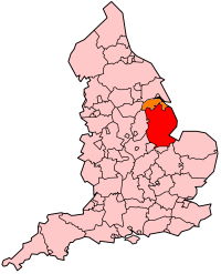
Lincolnshire's Location within England |
|
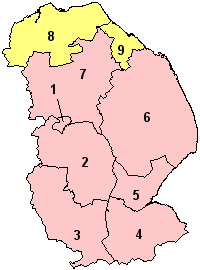
- Lincoln
- North Kesteven
- South Kesteven
- South Holland
- Boston
- East Lindsey
- West Lindsey
- North Lincolnshire
(Unitary)
- North East
Lincolnshire (Unitary)
|
Lincolnshire
(abbreviated Lincs) is a county in the East Midlands of England.
It borders onto Norfolk, Cambridgeshire,
Rutland, Leicestershire,
Nottinghamshire, South
Yorkshire, the East Riding
of Yorkshire and (for just 19 metres, England's
shortest county boundary) Northamptonshire.
Its county town is the ancient city of Lincoln.
| Geography |
| Status |
Ceremonial &
(smaller) Non-metropolitan county |
| Region |
East Midlands
(North Lincolnshire and
North East Lincolnshire are in
Yorkshire and the Humber) |
Area
- Total
- Admin. Council
- Admin Area |
Ranked 2nd
6,959 km²
Ranked 4th
5,921 km² |
| Admin HQ |
Lincoln |
| ISO 3166-2 |
GB-LIN |
| ONS code |
32 |
| NUTS 3 |
UKF30 |
| Demographics |
Population
- Total (2004 est.)
- Density
- Admin. Council
- Admin Pop.
|
Ranked 19th
987,700
142 / km²
Ranked 15th
673,500 |
| Ethnicity |
98.5% White |
| Politics
|
| Executive |
Conservative |
| Members of Parliament |
Ian Cawsey, Quentin
Davies, John Hayes, Douglas Hogg, Edward Leigh, Shona McIsaac, Gillian
Merron, Austin Mitchell, Elliot Morley, Mark Simmonds, Peter Tapsell |
Geography
The ceremonial county
of Lincolnshire (composed of the administrative
county of Lincolnshire, plus the unitary authorities of North Lincolnshire
and North-East Lincolnshire) is the second largest of the English counties
and one that is predominantly agricultural in character. Despite its relatively
large physical area, it has a comparatively small population (of less
than 1 million people). The unusually low population density that arises
gives the county a very different character to the much more densely populated
and urbanised counties of south-east and northern England, and is, in
many ways, key to understanding the nature of the county (and perhaps
even its people).
Despite the widespread
perception of Lincolnshire as a physically
rather dull and uniform county, it is often remarked that the Lincolnshire
landscape is a place of surprising contrasts that possesses a subtle beauty
and quiet charm that is all of its own. Certainly its generally flat landscapes,
'big skies' and comparative emptiness make this a landscape that remains
uncommon in the generally densely populated United Kingdom. Although,
in terms of overall attractiveness, the county cannot be fairly compared
to the more dramatic and scenic, 'tourist friendly' landscapes of nearby
Yorkshire, Derbyshire
or Norfolk, the Lincolnshire landscape does have
much to recommend it to those prepared to get off 'the beaten track' and
explore what remains a lesser known and peaceful corner of an increasingly
hectic country.
For the purposed of
a general geographical classification the county can be broken down into
a number of sub-regions:
- Lincolnshire Fens:
a region of flat, marshy land (much of it reclaimed from the sea) that
predominates in the southern and south-eastern areas of the county (most
particularly around the local towns of Boston
and Spalding and extending
around The Wash to the county border with Norfolk.
- Lincolnshire Wolds:
a range of low hills that run broadly south-east through the central
and eastern portion of the county.
- The Industrial
Humber Estuary and North-East Coast: the major population and industrial
centres of northern and North-East Lincolnshire. These include the major
fishing port of Grimsby and
nearby Immingham (an important
centre for the chemical industry) - both towns are on estuary of the
River Humber, which flows into the North Sea). Also included is the
nearby industrial town of Scunthorpe,
a once important steel producing town, but now somewhat in post-industrial
decline.
The highest point
of the county is just to the north of the village of Normanby
le Wold, in the Lincolnshire Wolds north-east of Market
Rasen. Marked by a trig point, it is 168m/551ft high and is a Marilyn.
The
Greenwich Meridian
The Greenwich Meridian
runs through the county. It extends from the Humber estuary between Cleethorpes
and Humberstone at 53°33'14?N,
00°00'00?W1 and passes through Louth
and Boston before leaving the
county south of Gedney Hill
at 52°39'49?N, 00°00'00?W1.
Towns and Villages
The non-metropolitan
county of Lincolnshire is characterised by
the absence of any major urban area. The principal settlements and their
populations are: Lincoln (85,000),
Boston (35,000), Grantham
(34,000), Spalding (22,000)
and Stamford (19,000). Many
of the towns in the county continue to hold a weekly market, a centuries-old
tradition reinvigorated recently by the growth of farmers' markets. Most
of the urbanised area of Lincolnshire is on
the Humber estuary, in the unitary authorities. Scunthorpe
in North Lincolnshire, has a population of 62,000, and the Cleethorpes/Great
Grimsby conurbation in North East Lincolnshire has a population of
over 100,000.
Transport
Roads
Being on the
economic periphery of England,
Lincolnshire's transport links are less well developed than many other
parts of the United Kingdom. The road network within the county is dominated
by single carriageway trunk roads (A roads) and minor roads (B roads)
rather than motorways or dual carriageways - the administrative
county of Lincolnshire is one of the small number of UK counties without
a motorway (the M180, the principal link between South
Yorkshire and the North Sea coast, runs exclusively within the boundaries
of North Lincolnshire). Following a north-south axis the most important
route into and out of the county is the A1 (formerly the Great North Road)
linking the county with London and south-east England
as well as the important population centres of northern England and Scotland.
The three main points where traffic enters the county from the A1 are
Stamford, Grantham
and Newark (A46). The volume of
traffic on the A46 along with the extremely high accident rate forced
the County Council to transform the road to a dual carriageway along its
entire 20km (13 mile) length with this much needed upgrade being finally
completed in 2004. Up until a few years ago, it was said that there was
only approximately 35kms (22 miles) of dual carriageway in the whole of
Lincolnshire
Partly because of
its fast and flat (but deceptively undulating) roads, Lincolnshire
has one of the worst road accident records of the UK counties (as measured
in terms of road fatalities per head of population). In a national effort
to cut the number of speed-related deaths and injuries, the county's residents
became early guinea pigs in a programme to roll-out speed cameras across
the country and (much to the annoyance of many of its residents) Lincolnshire
now has 52 speed cameras installed on its road network.
Rail
The low population
density of the county means that the number of railway stations and train
services is rather low considering the county's large physical size. A
large number of the county's railway stations were permanently closed
following the Beeching Report of 1963. Lincoln
retained its direct train service to London until
the late 1980s, but it is now necessary to change trains in Newark,
Nottinghamshire. However, the East Coast Main Line passes through
the county and so it is still possible to catch direct trains to the capital
from Grantham.
There is a local joke
that Lincolnshire is the only county where
most people's second car is a Massey-Ferguson (a make of tractor).
Bus
Bus services within
the county are also limited in number, due to the inherent economic feasibility
of serving a scattered population living across an area with low population
density. Many smaller villages in the county have no regular bus service,
making access to a private vehicle the only practical means of living
in many parts of the county. The services that do exist almost exclusively
service the large population centres (e.g. Lincoln,
Grantham, Boston,
Skegness) and mid-sized market
towns (e.g. Horncastle, Gainsborough)
and a limited number of their dormitory and commuter villages. Lincolnshire
Road Car was bought out by Stagecoach in late 2005.
Airports
Lincolnshire
has its own airport in the north of the county at Kirmington
(a former RAF bomber airfield), between Scunthorpe,
Grimsby and Lincoln.
Several others are fairly easily accessible by either road or rail.
Humberside Airport
(HUY)
Doncaster 'Robin Hood' Airport (DSA)
Nottingham East Midlands Airport (EMA)
Leeds-Bradford Airport (LBA)
Stansted Airport (STN)
Manchester International Airport (MAN)
Canals
Lincolnshire
is served by the Foss Dyke canal, an ancient waterway of Roman origin,
which connects the River Trent and the River Witham.
History of
Lincolnshire
Lincolnshire,
England derived from the merging of the territory of the ancient Kingdom
of Lindsey with that controlled by the Danelaw borough Stamford. For some
time the entire county was called 'Lindsey', and it is recorded as such
in the Domesday Book. Later, Lindsey was applied only the northern core,
around Lincoln, and emerged as
one of the three 'Parts of Lincolnshire', along with the Parts of Holland
in the south-east and Kesteven in the south west.
In 1888 when county
councils were set up, Lindsey, Holland and Kesteven each received their
own separate one. These survived until 1974, when Holland, Kesteven, and
most of Lindsey were unified into Lincolnshire,
and the northern part, with Scunthorpe
and Grimsby, going to the newly
formed non-metropolitan county of Humberside, along with most of the East
Riding of Yorkshire.
A further local government
reform in 1996 abolished Humberside, and the parts south of the Humber
became the unitary authorities of North Lincolnshire and North East Lincolnshire.
These areas became part of Lincolnshire for ceremonial purposes such as
the Lord-Lieutenancy, but are not covered by the Lincolnshire police.
These two authorities are in the Yorkshire and the Humber region.
The remaining districts
of Lincolnshire are Boston, East Lindsey, Lincoln, South Holland, South
Kesteven, North Kesteven and West Lindsey. They are part of the East Midlands
region.
Pre-Roman and Roman
Lincolnshire
before the Romans was a Druid nation, a subdivision of the Iceni tribe,
called the Coriceni, and were driven to this part of the country by the
Celtic Gauls around 300 BC. Several small barrows from this period have
been discovered near Boston and
Frampton.
The Romans had established
permanent government in Lincolnshire by 43
AD, but the tyrannical rule of the Roman sub-prætor Ostorius Scapula
so inflamed the Coriceni and their neighbours in Yorkshire,
the Brigantes, that they conducted a simmering low key rebellion lasting
well into 70 AD.
Eventually, the Governorship
of Britain was given to the Deputy of the Prefect of Gaul and the title
Vicar of Britain created. He resided at York,
and the sub-district of Flavia Cæsaeriensis, which comprised Lincolnshire
and parts of the Midlands created.
Once established,
the Romans set about improving Lincolnshire.
They cut drains such as the Car Dyke, which ran from the River Welland
at the eastern end of Market Deeping for forty miles to the River Witham
at Fiskerton. They also dug
the navigable Fossdyke, running from the River Witham at Lincoln
to the River Trent, at Torksey,
and the River Westlode, which drained water from the fens into the River
Welland.
They also constructed
sea defences, raising a large earth bank running along the coast some
thirty miles from Ingoldmells
to Boston, known now as Roman
Bank. There is evidence that they were assisted by the Coriceni, and by
expert foreigners, possibly the Dutch. They also constructed hard standings
and walkways across the fens, and inland ports such as the Brayford Pool
at Lincoln.
The main Roman forts
in Lincolnshire were:
- Alkborough (Aquis)
- Ancaster (Causennis)
- Brant Broughton
(Briga)
- Caistor
- Broughton (Pretorium)
- Horncastle (Banovallum)
- Kirton in Lindsey
(Inmedio)
- Lincoln (Lindum
Colonia)
- Ludford
- Stow (Sidnacester)
- Tattershall (Drurobrivis)
- Torksey (Tiovulfingacester)
- Wainfleet (Vainona)
- Willoughby (Verometum)
- Winteringham (Ad
Abum)
Three roads in the
future Lincolnshire were used by people following the Antonine Itinerary:
- Ermine Street
- Fosse Way
- Tillbridge Lane
Other roads of Roman
origin are the Salters' Way, continuing the line from the Leicestershire
border across Ermine Street near Old
Somerby, to the then coast at Donington. King Street including The
Long Hollow road, joined Ancaster
to the fen edge and Durobrivae near Peterborough.
Two roads linked Lincoln to the
coast across the Wolds. This was used as part of the defence system set
up to protect the Saxon Shore and re-used by William the Conqueror in
conjunction with Lincoln Castle. There are also scores of smaller sections
of roads branching off from the three major routes which are certainly
Roman as well, linking Ermine street with the Wolds and King Street with
the coast. Also, Mareham Lane continued the fen-edge line of King Street
northwards.
When the Romans departed
in 448 AD, all these works gradually fell into ruin and disrepair.
The Saxons and the Danes
The Britons,
left to there own devices by the Romans, quickly fell into anarchy, but
external attacks by the Picts and Scots forced the Britons to organise
into military dictatorships, and cooperate to repel the threat. However,
the size of the military threat was such that they were forced to hire
Saxon Mercenaries to help then, and no sooner had the Picts and Scots
been defeated and repelled, then the Saxons turned on the Britons, who
were by now led by Vortigern and the legendary King Arthur.
Arthur almost succeeded
in ejecting the Saxons, but died in 520 AD and the Britons, now lacking
a strong leader, were swept back again by the Saxons, who by now consisted
of two tribes, the Jutes, and the Angles, from which the term Anglo-Saxon
derives. This was no easy conquest — it took 111 years from the
death of Arthur to the establishment of the Saxon Heptarchy, as the seven
kingdoms of Kent, East Anglia, Essex, Sussex, Wessex, Northumbria and
Mercia were known.
Mercia was the largest,
comprising Lincolnshire, Nottinghamshire,
Staffordshire, Worcestershire
and parts of some other counties; Lincoln
was its capital city. There is a modern aphorism: "Lincoln was, London
is and York shall be / the greatest city of the three". The Druid
culture of the Britons that the Romans were quite happy to let alone was
now crushed and the pagan sun and moon worship of the Saxons prevailed.
This alarmed the then-Pope, Gregory I, and in 590 AD he sent Augustine,
a roman monk, and in 628 AD, Paulinus, to England to convert the heathens.
Paulinus did so, baptising hundreds of Saxons and Britons in the River
Trent near Torksey.
The Kingdom of Mercia
existed for about 300 years.
The lasting legacy
of this period was the division by Alfred the Great of the County into
areas of land using Feudal measurement.
In 768, the Danes,
lead by Hinguar and Hubba, lead an invasion force and landed at Humberstone,
near Grimsby. They burnt, looted,
raped and pillaged their way across Lincolnshire,
destroying the Abbeys at Crowland and Bardney, and murdering the monks.
The Norman Conquest
The Anglo-Saxon nobility
of Lincolnshire was destroyed by William the
Conqueror, and the lands divided amongst his followers. He constructed
Lincoln Castle, and another at Tattershall,
and imposed a curfew on the populace.
The English Civil War
During the
war, Lincolnshire was part of the Eastern
Association, the Parliamentarian alliance. On its western border lay the
Royalist strongholds, of Newark
on Trent and Belvoir Castle. Lincolnshire
was therefore raided and defended by the respective parties. For a time,
Crowland, in the south of the
county was fortified for the king.
Lincolnshire
was important to the Parliamentarians as it provided access between the
great arsenal of Hull and the south and the Eastern Association's heartland
in the east of England. It also offered a potential starting line for
an advance across the English midlands, cutting the north of England off
from the west.
World War Two
The RAF in WWII
Lincolnshire
was a largely unvisited, peaceful agricultural backwater until World War
Two when a large number of Royal Air Force bases were built around the
county, expanding the large number already present. By 1945 the number
of RAF bases exceeded 46. The very first airfields were built for the
Royal Flying Corps. The first Royal Flying Corps of theses bases was built
at Skegness, on the Lincolnshire
coast in 1912. Amongst other famous RAF bases in the county that were
constructed were RAF Cranwell, the Officer Training College, RAF Swinderby,
the main Recruit Training Camp, and RAF Scampton, the home base of 633
Squadron.
Lincolnshire
still has the strongest claim to being the 'home' of RAF Bomber Command,
playing host to many squadrons, including the Lancaster bombers of the
famous 617 'Dambusters' squadron who were based at RAF Scampton. There
were two Bomber Groups based in the county - No. 1 in the north and No.
5 Group in the centre and south. The Battle of Britain memorial flight
is still led by a Lancaster named 'The City of Lincoln'.
Most of the airfields
were closed after the war and, although most have been built over, disused
airfields, abandoned control towers and crumbling concrete bunkers and
airfield buildings remain a physical feature of the county in a number
of places. Many people in Lincolnshire have
learned to drive a car on the disused concrete airstrips of the county.
Cold War History
RAF Waddington and
RAF Scampton formed two of the main bases for the V Bomber Force, flying
Vulcans, during the Cold War, while Thor missiles were stationed on former
wartime air stations at for example, RAF Folkingham.
Economy
Agriculture
The county
of Lincolnshire is a major agricultural producer, growing large amounts
of Wheat, Barley, Sugarbeet and Oilseed rape. In South Lincolnshire, where
the soil is particularly rich in nutrients, some of the most common crops
include cabbage, cauliflowers and onions.
Mechanisation around
the turn of the 20th Century greatly diminished the number of workers
required to manage the county's relatively large farms, and the proportion
of workers in the agricultural sector dropped substantially during this
period.
Today, immigrant workers
from Southern and Eastern Europe comprise a large component of the seasonal
agricultural workforce, particularly in the south of the county where
more labour intensive crops such as small vegetables and cut flowers are
typically grown. Many of these migrant workers are from the southern and
eastern states of the European Union and are thus working legally in the
United Kingdom. However, anecdotal evidence suggests that a substantial
amount of casual illegal labour from countries beyond the EU is also employed
within the county's agricultural workforce. This seasonal influx of migrant
labour occasionally causes tension between the migrant workforce and local
people, in a county which is still relatively unaccustomed to the large
scale immigration experienced by other parts of the United Kingdom.
Services and Retail
According to
an IGGI study in 2000 (source), the town centres were ranked thus:-
Public services
Education
Lincolnshire
is one of the few counties within the UK that still uses the Eleven plus
to decide who may attend grammar school. Despite the bias towards selection,
there are many comprehensive schools in Lincolnshire
with excellent records.
Notable schools in
the county include the following:
- Skegness Grammar
School - notable as the first school in Great Britain to apply for and
receive, 'grant-maintained' status.
- King Edward VI
Grammar School, Louth also uses the Eleven plus to select pupils. The
school recently celebrated it's 450th Charter Day in 2001 to mark the
day, on September 21st 1551, when King Edward VI signed the charter
to maintin the school's existence following the dissolution of the religious
guilds and the monastery in the town. Former pupils of 'KEVIGS' include
Captain John Smith founder of Virginia, Sir John Franklin and Alfred
Lord Tennyson.
- Boston Grammar
School is another ancient educational institution, having been founded
by charter of William and Mary in 1555. It was used as the model for
Boston Latin School which was the first school of the new colony in
what became the United States of America. Boston Grammar School's current
library, built in 1567, is believed to be the oldest academic building
in continuous use in England.
Despite the bias
towards selection, there are many comprehensive schools in Lincolnshire
with excellent records. The Priory (formerly the Lincoln School of Science
and Technology) is well regarded and achieves results comparable with
the selective schools. William Farr School at Welton recently topped the
national list for 'A level' results and was described in a recent OFSTED
report as "outstanding".
Health care
The United
Lincolnshire Hospitals NHS Trust is one of the largest trusts in the country,
employing almost 7000 staff and with an annual budget of over £250
million.
Lincolnshire
shares the problems of elsewhere in the country when it comes to finding
an NHS dentist, with waiting lists of three months not uncommon.
Some of the larger
hospitals in the county include:
- Boston Pilgrim
Hospital
- Grantham and District
Hospital
- Lincoln County
Hospital
- Skegness and District
General Hospital
People
Lincolnshire
is relatively unusual in the composition of its population, being one
of the least ethnically diverse counties of the United Kingdom (98.5 percent
of the population describe themselves as "white"). Over recent
years inward migration by people from ethnic minority communities has
increased (particularly to population centres such as Lincoln)
but the absolute number of non-white Lincolnshire residents remains very
low.
Recently, the county
has also witnessed a growing trend towards an in-migration of retired
persons from other parts of the United Kingdom, particularly those from
the southern counties of England
attracted by the generally lower property prices and generally slower
and more relaxed pace of life. Skegness
was recent voted the most popular place in Britain to retire to, with
Spalding and Mablethorpe
also recommended, by a recent study. The relatively high proportion of
elderly and retired people is reflected in many of the services, activities,
and events.
Those born in Lincolnshire
are sometimes given the slighly comic nickname of Yellowbellies (often
spelt "Yeller Bellies", to reflect the pronunciation of the
phrase by the typical Lincolnshire farmer). The term is thought to refer
to the flat and open landscape in the south - if a farmer wanted to hunt
he would have to lie on his belly to avoid being spotted by his prey.
Culture
Lincolnshire
is a rural area where the pace of life is generally slower than much of
the United Kingdom. Sunday is still largely a day of rest, with generally
only shops in Lincoln, larger
market towns, and resorts and industrial towns of the North Sea coast
remaining open. Some towns and villages in the county still observe half-day
closing on Thursdays. Lincolnshire has a large
cehlidh dancing fan base and it is not unusual for the many village and
town halls to hold dances. Fishing (because of the extensive river and
dyke system in the fens) is very popular.
Language
The accent
and dialect words of Lincolnshire are poorly
known beyond the county, especially compared to more familiar accents,
e.g. Scouse or Cockney. The effects of modern media, education, and in-migration
to the county have substantially diluted the traditional accent, and many
dialect words have been lost over recent years. However, the accent certainly
exists, and a native 'Yeller Belly' will still easily pick out a Lincolnshire
speaker, possibly even being able distinguish where in the county the
speaker is from. The northern residents of Lindsey tending towards the
Yorkshire dialect, with the accent of the south-east of the county (Holland
and the Fens) being more similar to that of East Anglia.
In common with most
other Northern and Midlands dialects in England, "flat" a is
preferred, and also in words like water, pronounced watter (though such
a pronunciation is rarely heard in 2005).
Lincolnshire has
its own dialect 'champion', a farmer from the village of Minting called
Farmer Wink (real name Robert Carlton), who has produced videos about
rural life, narrated in his broad Lincolnshire accent, and who has a regular
slot on BBC Radio Lincolnshire.
Food
Lincolnshire
has a number of interesting local dishes:
- stuffed chine -
this is roasted and sliced belly of pork, stuffed with a strong sage,
or parsley stuffing (other ingredients are normally kept secret). Served
cold, it's considered by many in the county to be an acquired taste
- haslet - a type
of pork loaf, also flavoured with sage
- Lincolnshire pork
sausages - most butchers in Lincolnshire have their own secret recipe
for these and a competition is held each year to judge the best sausages
in the county
- Batemans ales
- a beer brewed in Wainfleet and served in many pubs in the county and
further afield
Events
Every year
the Lincolnshire Agricultural Society stages the Lincolnshire Agricultural
Show on the last whole week of June at its showground at Grange
de Lings. First held in 1869, it is one of the largest agricultural
shows in the country, and is attended by around 100,000 people over its
two day opening.
Since World War II,
RAF Waddington has been home to the Waddington International Air Show,
which usually takes place on the last weekend in June. The two day event
attracts around 100,000 people each year.
Symbols
The unofficial
anthem of the county is the traditional folksong, 'The Lincolnshire Poacher',
which dates from around 1776. A version of the song was the theme to BBC
Radio Lincolnshire for many years.
In August 2005, BBC
Radio Lincolnshire and Lincolnshire Life magazine launched a vote for
an unofficial flag to represent the county. Six competing designs were
voted upon by locals. The winning submission was unveiled in October 2005
see here.
Places of
Interest
- Alford Manor
House
- Alford Windmill
- Alkborough
Turf Maze
- Ayscoughfee
Hall
- Belmont
Transmitter (tallest construction in the European Union)
- Belton House
- Bolingbroke
Castle
- Boston Stump
- Branston
Hall
|
- Cogglesford
Watermill
- Crowland
Abbey
- Doddington
Hall
- Dunston
Pillar
- East Lighthouse,
Sutton Bridge
- Gainsthorpe
- Grimsthorpe
Castle
- Harlaxton
Manor
- Heckington
Windmill
- Lincoln
Castle
|
- Lincoln Cathedral
- Lincolnshire
Aviation Heritage Centre
- Natureland
Seal Sanctuary
- Normanby
Hall
Gibraltar Point
- River Ancholme
- Tattershall
Castle
- The Collection
- The Wash
|
This
article is about the English administrative county. For the Illinois
village, see Lincolnshire,
Illinois; for the Kentucky
city, see Lincolnshire,
Kentucky.
|